Forums › Western Europe › United Kingdom › Updating Road Priorities in Rural Areas
-
 Andrew Gransden • May 31, 2017 at 7:20 am UTC
I am seeking some general advise for contributors on updating the road priorities in rural areas. I will use as an example the B9016 from Keith to Portgordon/Buckie.
In the UK most roads outside urban areas default to the national speed limit (60mph). This includes all categories of road such as back roads and country lanes. I note that the average speed is generally set to 40mph but for narrow single track roads you would be lucky to average 30mph especially with on coming traffic and the need for passing places.
As a result my SatNav (Honda Garmin Navigator with 2017.0 map), will attempt to route me off the ‘main’ road (A or B) onto an unsuitable narrow unclassified road. For example, travelling north from Keith (in Moray, Scotland) to Buckie on the popular B9016, I am directed off the 2 lane B road onto the shorter unclassified road to the A96. This lane changes from 2 lanes to a very narrow single track barely suitable for cars but used extensively by farm traffic. See attached images.
I have posted map notes and suggested changes to the speeds along this unsuitable lane. I have yet to see any feedback. The problem is not unique and guidance is requested on how to best feedback such cases. There also needs to be a new road category for single track in both directions.
Andrew Gransden • May 31, 2017 at 8:29 am UTCI tried to upload images but they have not appeared.
Claire Robinson – HERE UK and Ireland • May 31, 2017 at 2:33 pm UTCHi Andrew, thanks for starting the discussion on this.
We have historically done several updates on these type of roads you mention to try and better reflect reality and to improve the very guidance issues you mention that may occur in different navigation systems based on their speed routing algorithms. We have previously bulk dropped the speed category on these type of roads we have identified that may cause these issues (rural, narrow, unpaved roads etc)
As you can appreciate, this is an ongoing process and your local knowledge and feedback is much appreciated. Please do continue to lower the speed category on these roads, as you have been doing as this is currently the best way to report and ensure a change is ultimately made to your routing.
I have looked at your edits in the area you mention and these have now been accepted into the system.
We’re continually working on the Map Creator interface and it’s editable features, but of course these have to align with our strict specifications and quality processes, hence the current road type classification we have in Map Creator.
Thanks again for your continued enthusiasm and engagement in Map Creator 🙂 Andrew Gransden • June 1, 2017 at 8:16 am UTCThank you Claire. I can see that a number of my changes across the area have been accepted. I was a little confused as several relating to the B9016 (mentioned above) have ‘no been accepted’ but looking at the overall average speeds for the B9016 and the narrow side lane are showing as ‘correct’ values (54 mph and 40/30mph).
There is one issue with Map Creator. When signed in you can see your ‘latest’ edits reflected in the map. What would be useful to see is an optional to switch off your edits to see the ‘official’ map status and another option to highlight on the map changes that have been accepted or rejected. These could be switchable layers.
Claire Robinson – HERE UK and Ireland • June 2, 2017 at 9:41 am UTCGood suggestion Andrew, we are constantly looking for feedback on what our users would like to see and how they would like to use the tool, so I’ve fed this back to the engineering team. As usual, we’ll keep you updated in our newsletters and on our Facebook site with new Map Creator functionalities. Have a great weekend!
Andrew Gransden • June 5, 2017 at 8:21 pm UTCFurther to this discussion, can I ask for a clarification on the different between Residential and Local Access roads? Many roads are classified as Residential where is my area of Scotland there are very few residents.
Of the roads categories, Highways are motorways/autobahns/freeways, Main roads are trunk/A roads, Local Access appears to be listed as B roads and all other paved roads are listed as Residential. These are obviously based on urban rather than rural road infrastructure. I can accept that. However, can we have should guidance issued?
Going back to my example of the B9016 (Keith to Portgordon) I submitted changes to ‘upgrade’ this B road from Residential to Local Access. Some of this have today been rejected without explanation. Surely, local knowledge should take priority over a specialist who does not know the area or roads.
Benjamin Leese • June 20, 2017 at 3:11 pm UTCHi Andrew,
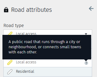
The guidance you are looking for is available from a pop up help hint. Select a road to edit then hover the question mark for expanded information. An example can be seen in the imageThe HERE database is built up on a hierarchy of roads to help and define routing ranging from FC1 (typically a motorway and majors A Road), FC2 (A roads), FC3 (B Roads) ,FC4 (connecting roads) and FC5 residential roads. These are only loose definitions and some types of road may change function class if they are bypassed for example.
Road type labels are a handy guide to community members that can be applied worldwide. Clearly a community user in Germany wouldn’t understand terms such as A road or B road. If a function class change is proposed by a community member, the indicated road type can help implement this.In your query the B9016 should have been Local access FC4 so I’m unsure why it was residential- perhaps another recent community user had edited it. I’ve checked all your edits along the B9016 and made sure they are local access road. It remained an FC4 in our published data.
Thanks for your inputs.
Ben Andrew Gransden • June 27, 2017 at 10:21 am UTCThank you Benjamin for the explanation and corrective action.
Mike Archer • June 28, 2017 at 12:03 pm UTCBenjamin, are you sure that a B road should be set as Local Access? Looking at any area of the UK on the map editor, almost all B roads are set as Residential, and A roads are either Main Roads or Local Access.
-
This reply was modified 7 years, 1 month ago by Mike Archer.
Andrew Gransden • June 28, 2017 at 12:16 pm UTCMike, you need to bear in mind that we are talking about rural areas here. In parts of Scotland, main A road can be a ‘single track’ road with passing places or no better than B roads in southern England. Others are better – dual or wide 2-way roads. Many of our trunk roads have been de-trunked but remain key main roads. Our B roads fill in the gaps but remain local access (i.e. joining 2 towns) and can have few properties so they are not truely Residential by any use of the term.
My point was that many rural roads had the national speed limit set (60mph) which leads the navigation systems sending unsuspecting motorists down narrow and windy unclassified roads. This side roads are in many cases unsuitable for large/heavy vehicles. I don’t think this is the intention.
Not all roads are created equal.
Mike Archer • June 28, 2017 at 12:46 pm UTCAndrew, I understand your point, and I have the same problems where I live in that the route chosen is often down narrow back roads. I think it would be better if B roads were marked as local access, as Benjamin, implied they should be, however this is not the case, and there seems to be no logic behind which ones are. For example near me all the B roads are marked as residential roads bar one. The one marked as local access has a 40mph limit for most of the road, whilst all the national speed limit or 50mph roads are marked as residential.
Claire Robinson – HERE UK and Ireland • August 2, 2017 at 2:14 pm UTCHi Mike, to elaborate on what Ben has posted so far – sort of unfortunately at the moment, indeed, the road types within Map Creator are currently being used globally and thus, are not necessarily applicable enough for all of our UK and Ireland countries. Along with that, the functional class system we use does not match as closely as it should to the road types and descriptions in Map Creator – to try and ensure it is as simple and straight forward for a Map Creator user, without going into our extensive internal specifications to ensure automotive grade. The ones you mention marked as ‘residential’ Mike would be ‘FC5’ and correct to the areas to have them as this functional class – for routing and navigation purposes primarily of course.
We are currently working on changes to the road types and their respective descriptions within Map Creator to try and reflect better each countrys specific road network.
Thanks Mike Archer • August 4, 2017 at 12:10 am UTCThanks for the reply, it’s good that this problem is recognised and is going to be solved in the future. I think, maybe in the meantime, it’s a good idea, as mentioned, to mark down the average speed on these single track roads to a realistic speed (many are marked at 40 or 60 mph). It would be a great help in correcting these if the option in map creator to highlight roads by their speed limit could be toggled to show their marked average speed instead of the speed limit, then people could quickly identify and correct the problem roads in their local area.
Andrew Gransden • August 4, 2017 at 9:59 am UTCI totally agree with Mike’s suggestion of being able to see the average speeds set for roads in addition to the speed limits.
Note: There is a bug in Map Creator that after cancelling Speed Limits overlay that you have to refresh the page before you can add new roads.
-
This reply was modified 7 years, 1 month ago by
You must be logged in to reply to this topic.