Forums › Western Europe › United Kingdom › Loss of definition of aerial images in Mapcreator
-
 Terry Bates • December 29, 2023 at 4:11 pm UTC
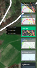
Presume it’s not just me that has found the aerial images are now pixelated, making it pretty impossible to use Mapcreator. Is there a time horizon to fix. ?. Looks like copyright has elapsed so they have been downgraded to make them unusable.
Example attached.
 Terry Bates • March 21, 2024 at 5:10 pm UTC
I’ve still got this issue. I did have assorted images that I could pull up and they have gone !.
Alternative images 1-3 are empty. Is this my profile needing to be sorted ?.
-
This reply was modified 4 months, 1 week ago by
 Terry Bates.
 Mihael Trankovski • April 19, 2024 at 8:31 am UTC
GREETINGS
all the pictures have disappeared, even for those of us who have a moderator map creator, there are no pictures even in the normal map creator for external users in the view of alternative 1, I got a reply from the support that the provider for supplying satellite images is changing, Terry Bates • April 19, 2024 at 9:24 am UTC
I was told by UK support its dependent on a new system going in but when, not known. Yes I think it was us former map masters in Europe who got the image alternatives. Suspect normal folk didn’t, but now, nobody does… Well I expect external to Here Maps. I can’t believe they are using these out of date images inside Here Maps. The system has reverted to how it was six years ago before the better image alternatives were introduced. You have to go back to your old workarounds.
 Mihael Trankovski • May 1, 2024 at 12:54 pm UTC
@Terry
all satelite image is back , beautifull , Terry Bates • May 1, 2024 at 5:59 pm UTC
I am find “something” is back, but not working correctly. The tile server isn’t managing to server up all the tiles, there are gaps. I tried Chrome rather than Firefox but the same. I think we have been here before from memory. Probably their servers aren’t quick enough. It may be dependent on which one you come up on or something. Still bit of an improvident but not beautiful with gapping holes in the images.
 Mihael Trankovski • May 2, 2024 at 11:18 am UTC
@Terry
please tipe-press to PC keyboard : F12 and which date you have a script ? mine is 02.04.2024 Terry Bates • May 2, 2024 at 12:21 pm UTC
Same as yours 2024.04.02
Tile server timing issue I believe. I’ve seen it when I’ve run a local tile server.
 Terry Bates • May 14, 2024 at 9:17 pm UTC
@Mihael Seems to have reverted to how it was, not working,
 Mihael Trankovski • May 15, 2024 at 8:43 am UTC
@Terry: Yes , you are correct , date is 2024.05.02 , not working ,
 Terry Bates • May 19, 2024 at 6:30 am UTC
@Mihael see what June produces. I haven’t told the Here Maps power’s that be that it was half working for me in May. I think it paints the tiles on top of each other but if they have a tile server issue that’s when you don’t get to see the higher definition tile written in. Least I think that’s what is going on.
 Mihael Trankovski • May 24, 2024 at 12:33 pm UTC
@Terry
it works fine now, it’s a little better, try it yourself if it’s ok Terry Bates • May 24, 2024 at 2:10 pm UTC
@Mihael Yes seems working fine at the minute.
 Mihael Trankovski • June 6, 2024 at 9:39 am UTC
@Terry
no satelite image , not working , date 05.02.2024 Terry Bates • June 7, 2024 at 5:52 pm UTC
@Mihael well its back again for me.
2024.05.02 script.
-
This reply was modified 4 months, 1 week ago by
You must be logged in to reply to this topic.

