Forums › Western Europe › United Kingdom › Can someone approve some minor edits in West Kyo, County Durham please?
-
 Ian Alexander Inman • September 8, 2018 at 4:19 pm UTC
I’ve made some minor edits in West Kyo, County Durham.
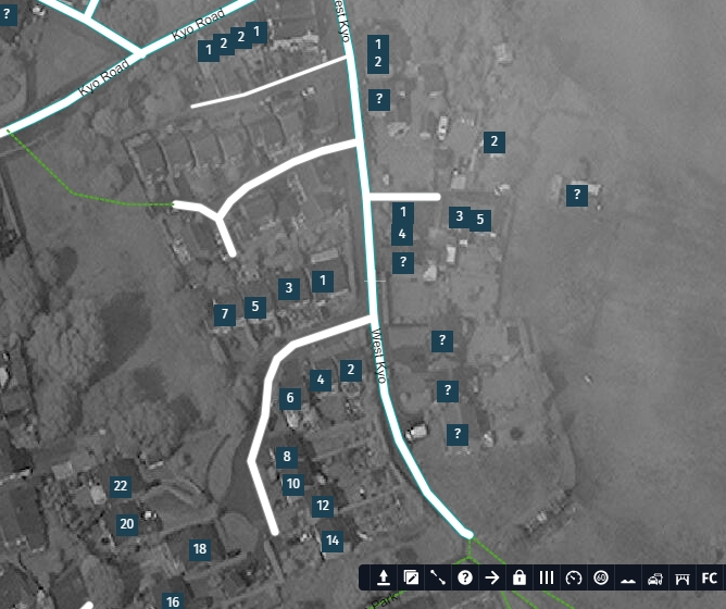
https://mapcreator.here.com/mapcreator/54.865229668269194,-1.737382948236501,20,0,0
There were a couple of sections of road incorrectly named Fairfield. These have been renamed Latchley House, Dunns Building and Dunns Yard respectively, based on streets within the village.
The problem is that SatNavs (satellite navigation systems) have been directing delivery drivers and postal services to the wrong addresses, leaving locals to take the post to the correct “1 Fairfields”, on a side road leading off the detailed sections of road.. This has been going on for some time.
I’d appreciate a speedy resolution as some of the incorrect deliveries have led to either post being delayed a number of days due to being to delivered to houses where people are away or in a number of cases, elderly people being disturbed and not making the front door in time to collect an incorrect delivery.
An extra side road that was previously missing has also been added.
Many regards,
Ian
-
This topic was modified 5 years, 7 months ago by Ian Alexander Inman.
Gordon HERE Map Master (Ambassador) • September 8, 2018 at 7:47 pm UTCthe edits you made are incorrect, the road should not be named after a building. if its a building then use the house tab and add the building as a name that way not add it to the road.
Gordon HERE Map Master (Ambassador) • September 8, 2018 at 8:11 pm UTCi have edited the correct building numbers in those areas as it should be properly done. You need to do the same for the rest of the area. use the house number tab to correctly add the numbers and building names.
Ryde Terrace and others should be the foot path behind Low Church Street and House numbers pointing to the path. and the 5 bungelows named “Ryde Terrace Bungalows” as building name and also number each address as 1,2,3,4,5 etc.
-
This reply was modified 5 years, 7 months ago by Gordon HERE Map Master (Ambassador).
Gordon HERE Map Master (Ambassador) • September 8, 2018 at 8:42 pm UTCalso, be aware, all footpaths must be marked as a trail not a pedestrian road. these are two completely different things and should always be marked correctly as such.
Ian Alexander Inman • September 9, 2018 at 6:35 pm UTCThe main thing is the road that is now labelled as “West Kyo” does not say “Fairfields” anymore. That should stop people’s Satnavs guiding them to the wrong location.
With reference to people’s remarks, West Kyo as a village is a little complex. Due to house demolitions in the old village, you literally do have streets with just two houses left in them. For example, “Latchley House” is actually a street with two houses remaining. Dunns Buildings was a street and is now just one house. Another street has two houses with one street label and two houses with another street label. And yes, it does people’s heads in and where they would fit in with your map creation conventions is unclear.
If just labelling the road “West Kyo” sorts out the main issue of confusing people’s Satnavs, so be it.
Thanks,
Ian
Gordon HERE Map Master (Ambassador) • September 10, 2018 at 10:38 pm UTCall edits I made are 100% accurate as been verified from councils details they have. Fairfield is the new development to the left with 22 properies and correctly numbered.
you cannot blame HERE for people not updating their satnavs with upto date data. HERE maps is about being accurate and that is what that area is now, accurate as per council housing/street allocations. -
This topic was modified 5 years, 7 months ago by
You must be logged in to reply to this topic.