Forums › Western Europe › Belgium › How should we code a road that is blocked on one side ?
-
 Rudy B • January 3, 2020 at 11:07 am UTC
Hi,,
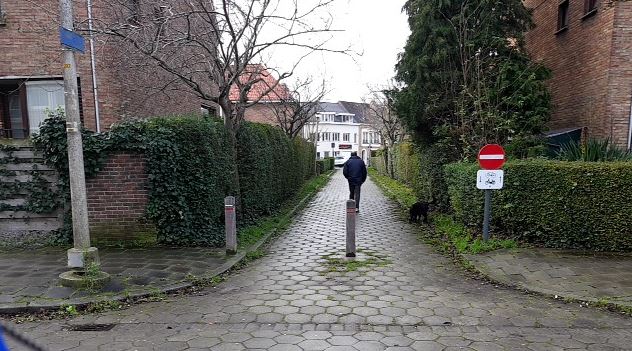
How should we code a road that is blocked on one side for all motorised traffic but is free for bycicles and pedestrians ?
(or is there is a webpage with this kind of information, ?)See example below.
From the far side, a car can drive in, but (in this case) needs to reverse outThanks
Best Regards
R. Borrey Rudy B • January 3, 2020 at 1:24 pm UTCJust wondering …..
Is this the right place to ask these kind of questions ??
Shoud I have started a discussion in Map Creator instead ??
Will a HERE professional respond to Map Creator discussions, or is that only between us volonteers ?Thanks
Alicja HERE • January 3, 2020 at 4:22 pm UTCHi R.Borrey,
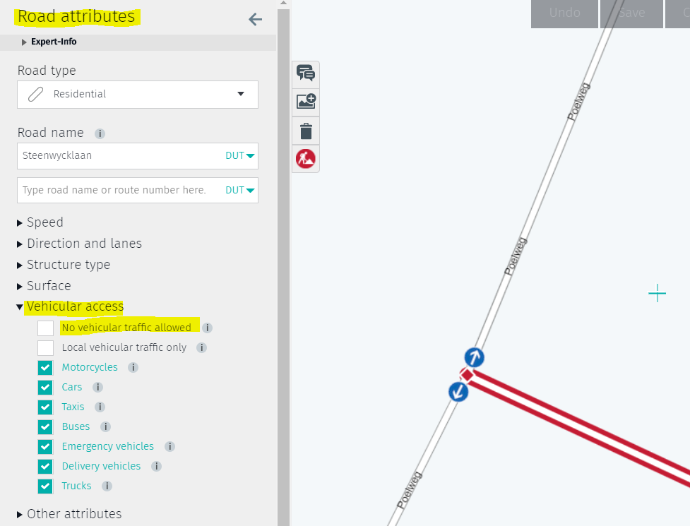
To update this information, you need to go to road attributes of this road. Under “vehicular access” you can change that access is not allowed for vehicular access (please see the image attached). However, please make sure you choose correct road type. Maybe in your case it’s for example a pedestrian road.
In order to read more about it, I would suggest you to read through our help pages. Here you can find all information on how to code a road and it’s attributes: https://mapcreator.here.com/mapcreator/help/roads-and-road-structure/road-attributes/
Besides help pages, you are welcome to our blog, where we post tips and tricks ( and other things) about Map Creator: https://whats-new-bnl.blog/
You are also welcome to our Facebook group! https://www.facebook.com/groups/heremapcreatorbenelux/
Greetings,
Alicja Gordon HERE Map Master (Ambassador) • January 5, 2020 at 9:46 am UTCthe part that is NOT accessible to vehicles should be edited as a TRAIL, and the part that can allow vehicles edited as RESIDENTIAL but tick only motorcycles, car, taxi and emergency vehicles only. and also tick LOCAL VEHICULAR TRAFFIC ONLY
Rudy B • January 5, 2020 at 4:15 pm UTCThanks Alicja & Gordon!
Gordon,, that was the information I was looking for. thanks!
Alicja HERE • January 6, 2020 at 8:32 am UTCYou’re very welcome R.Borrey! And thanks Gordon for your help – I agree with your comments.
Good luck and have a good day,
Greetings,
Alicja Rudy B • January 17, 2020 at 9:44 am UTCWell, I set the parameters for that road section according to the suggestions above, sadly, it was decided by HERE not to accept my changes, leaving that road section as it was in the HERE database (freely accessible for all traffic)
Now I changed the entire road section to trail. Hopefully that will get accepted …
Alicja HERE • January 17, 2020 at 11:57 am UTCThank you R.Borrey!
If it gets rejected, please let me know, so I’ll escalate it.Greetings!
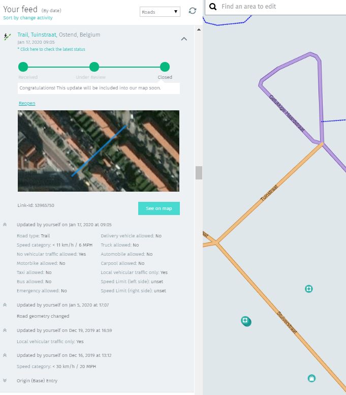
Alicja Rudy B • January 19, 2020 at 8:34 pm UTCWell Alicja, the good news is, it got accepted. (see left side of image below), but the bad news is that my change (to trail) was removed from the map (see right side of image). So I think nothing has changed in the HERE database.
You may remember I reported this sort of situation before, where the status of my feed was changed to accepted, but the change in the map was revoked. Only then it was in combination with somebody else also changing something on that same road section. Which in this case did not happen.
Thanks
R. Borrey Rudy B • January 20, 2020 at 7:18 am UTCI see that since my post last evening GORDON changed it back to trail.
As a strange result my feed seems to have received the status ‘under review’ again. even though I did not change anything .
Is it possible that the statusses we see in Map Creator, are not the statusses of our own feeds but the statusses of road segments changes – no matter who made them ??
You must be logged in to reply to this topic.