-
 Carl Schwarz • June 21, 2022 at 3:14 am UTC
Can someone direct me as to how to report/change truck attributes for an intersection?
In particular I found a road attribute that is wrong for trucks but is fine for cars.
The routing engine v8 allows cars to turn left at this particular junction but not trucks.
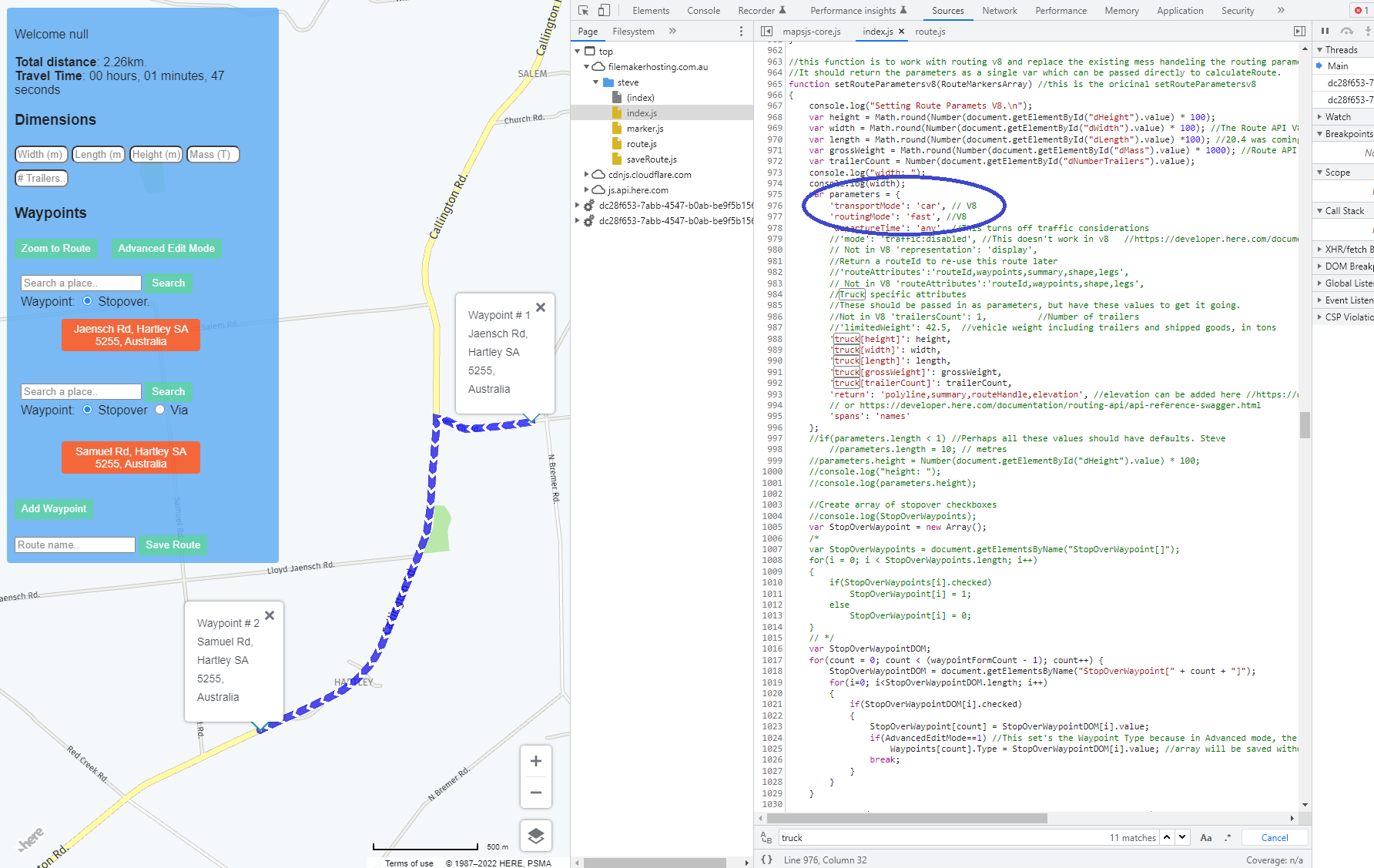
This is a particular problem since the intersection is near a truck yard that has around 40 trucks and a quarry.Just fyi. this is at the intersection of Jaensch Rd Callington Road in Hartley, south australia. The images attached are from our custom routing application and show that the route returned in “car” transport mode allows for the left turn, however in “truck” mode the route turns to the right and turns around and then comes back down the road.
-
This topic was modified 2 years, 1 month ago by Carl Schwarz.
Kevin Hutchison • June 23, 2022 at 4:00 am UTCAs far as I know the truck parameters are supplied by the GPS manufacturer not Here technology. I have not found the provision in mapcreator to capture data about height, wide length restrictions.
As an oversize vehicle escort driver I would find that data very usefull but found the Garmin version quite limited.
Carl Schwarz • June 23, 2022 at 4:16 am UTCHi Kevin Thanks but I am not sure what you mean by that. I am using the HERE Maps API’s directly. In particular HERE truck routing:
https://developer.here.com/documentation/routing-api/dev_guide/topics/truck-routing/truck-routing.html Kevin Hutchison • June 23, 2022 at 8:33 pm UTCAs a regular updater (77,000+ edits) of Here data, used in directing oversize load jobs here in Aus, I was not aware that the truck parameters are in the Here database, there is no mention of them in MapCreator where I provide the edits. I wonder at the volume of trucking data in the Australian rural areas.
We have experimented with one Garmin Denzl LGV700 truck GPS, but found the length/width selections quite limited, so we still use a dozen Garmin 2797, 2595, 2597, Drive 60, 61, 65 even a 256W unit, with over 60 custom POI routes for local mines. Even so I find it hard getting other drivers to provide changes needed so I am limited to the runs I do for data management. Carl Schwarz • June 23, 2022 at 10:16 pm UTCWhen applying for permits you would have noticed that the nhvr maps were supplied by here when the nhvr took over oversize permits from the states. Gazetted rt bd and oversize information is stored in Here I believe, it certainly was back then. Here maps was (is?) a treasure trove of truck map information. I’m just getting back into it now after a few years working elsewhere. Certainly being able to set truck specific information is a feature request for map creator!!!!!
Shona Chisholm • June 29, 2022 at 1:10 am UTCHi Carl & Kevin, Yes – as you’ve noted, you can’t edit truck specific parameters in Map Creator. We’ve contacted our local data team and they’ve made the change in our database so it should be reflected in the APIs soon, and other products as they are updated. Thanks for the feedback.
Nguyen Tra • July 8, 2022 at 4:13 pm UTCThiên Hạ Bet (thabet) is considered as the house that owns the largest and most diverse online game store. There are all forms of sports betting, attractive card games, etc. with high winning rates. Including prizes up to 5 billion VND. Please visit Thiên Hạ Bet to join
Robert Harmon • July 29, 2022 at 9:34 am UTCYou can’t edit “truck” road attributes. If I recall correctly, its simply a 10% chance that a road will be called a “truck” road. There are no special truck roads, they are just the same as any other road, just 10% more likely to be rated as a truck road. If you are talking about the street attributes, then unfortunately, no. You can not edit street attribute once created. But if you have a feature class for the road layer, the attribute table can be edited by the feature class function. Yes, you can change the type to “truck” but it seems it will not work as intended. The “truck” roads are only in the routing engine and not in the map. It is unclear if it will be available in the future. Source best cheap essay
Preston Glevos • September 23, 2022 at 12:30 pm UTCSOCVault is a security operations center as a service, SOC as a service, and SIEM as a service provider. SOCVault provides best-of-breed vendor solutions in one integrated platform to deliver the best security operations center experience to its customers. We have developed this unique solution on four pillars – Security Operations Center, Security Information and Event Management, Threat Intelligence, and Security Analytics.
Shawn Abi • September 26, 2022 at 1:51 pm UTCFor example, coats have more adjusted and organized shoulders, while overcoats’ style is more similar to that of unstructured rock walking tall jacket for sale: basic, with gentler shoulders and a laidback fit.
laura lorde • November 30, 2022 at 9:39 am UTCshell shockers – A great product from the blue wizard. Massively multiplayer online shooting game that appeals to everyone with its simple graphics and interesting maps.
tom lake • December 13, 2022 at 7:11 am UTCWe promise that your personalized basketball uniforms won’t bleed, crack, or seem transparent.. men custom basketball jersey
isabella mark • December 20, 2022 at 7:50 am UTCOne of my supply chain management dissertation topics writer friends told me that when you are using the intersection table to report or change truck attributes for an intersection, in the “Trucks” column, select the type of truck from the drop-down list.
taylo godiva • June 12, 2023 at 5:00 am UTCThe player’s task in the Geometry Dash Scratch game is to make moves to avoid obstacles at the right time to survive and constantly move towards the finish line.
Beau Sconce • December 20, 2023 at 5:23 am UTCruck parameters are in the Here database, there is no mention of them in MapCreator where I provide the edits. I wonder at the volume of trucking data in the Australian rural areas. MyDeal Coupon Code
-
This topic was modified 2 years, 1 month ago by

You must be logged in to reply to this topic.