-
 Michael Seymour • January 23, 2020 at 11:57 pm UTC
The HERE map says "Wilson Ln" but the signpost says "Wilson Rd"
Kevin Hutchison • January 24, 2020 at 1:53 am UTCSomehow the northern end has been labeled Wilson Rd and the southern end Wilson lane. The satellite photo shows it to be dirt is this still the case also.
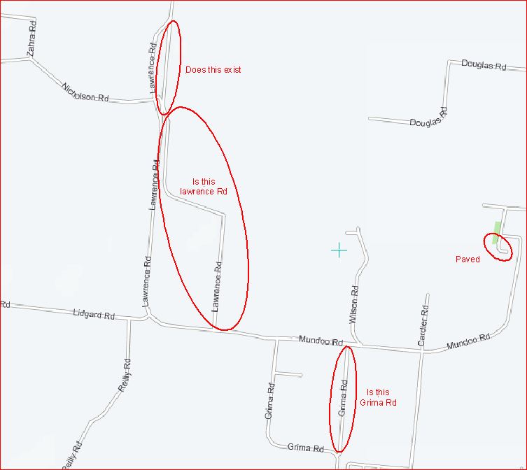
Lawerance Rd/Mundoo Rd also seems confused is it actually both or does Mundoo end at Wilson becoming Lawerance and are all paved as shown or unpaved.
Michael Seymour • January 25, 2020 at 5:12 am UTCLAWRENCE ROAD / MUNDOO ROAD NAMING CONFUSION
Yes, HERE Maps is currently confused with the Lawrence Rd/Mundoo Rd naming (HERE Maps, renames the road, BETWEEN INTERSECTIONS, for no apparent reason).
Please see my observations, below.LAWRENCE ROAD
I travelled along Lawrence Rd this morning, and noted:
a. Lawrence Rd is bounded by its intersection with Oak St at one end, and its intersection with both Lidgard Rd & Mundoo Rd, at the other end.
b. All the roads are clearly named and signposted, at the intersections.
c. Lawrence Rd is paved, throughout its length.MUNDOO ROAD
I travelled along Mundoo Rd this morning, and noted:
a. Mundoo Rd is bounded by its intersection with both Lidgard Rd & Lawrence Rd at one end, and its intersection with Aerodrome Rd at the other end.
b. All the roads are clearly named and signposted, at the intersections.
c. Mundoo Rd is paved, throughout its length.WILSON ROAD
I travelled along Wilson Rd this morning, and noted:
a. Wilson Rd is bounded by its intersection with Mundoo Rd at one end, and its dispersal amongst farm buildings, at the other end.
b. The signposting, at the Mundoo Rd intersection, says “Wilson Rd”.
b. There is no signposting, at the farm buildings, dispersal end.
c. Wilson Rd is dirt, throughout its length.Cheers,
Mick-
This reply was modified 4 years, 7 months ago by Michael Seymour.
Kevin Hutchison • January 26, 2020 at 1:01 am UTCLets lee if we can get this to reflect the rea world
LAWRENCE ROAD / MUNDOO ROAD NAMING CONFUSION
Yes, HERE Maps is currently confused with the Lawrence Rd/Mundoo Rd naming (HERE Maps, renames the road, BETWEEN INTERSECTIONS, for no apparent reason). Please see my observations, below. LAWRENCE ROAD I travelled along Lawrence Rd this morning, and noted:
a. Lawrence Rd is bounded by its intersection with Oak St at one end, and its intersection with both Lidgard Rd & Mundoo Rd, at the other end.
> Does the section to the east that crosses the rail to the south in the map actually exist it appears to not be there in the satellite photo.
> Is the alternate road to the east joining Mundoo rd signposted Lawrence rd also.
> Grima Rd to the east seems to also have the same dual possibilities.
> It is hard to differentiate road and rail in the satellite photo.
b. All the roads are clearly named and signposted, at the intersections. >fine
c. Lawrence Rd is paved, throughout its length.MUNDOO ROAD I travelled along Mundoo Rd this morning, and noted:
a. Mundoo Rd is bounded by its intersection with both Lidgard Rd & Lawrence Rd at one end, and its intersection with Aerodrome Rd at the other end. renamed all sections to Mundoo Road
> Is Lawrence Rd : Mundoo road just Mundoo rd as it was common for road names to be a combination of start and end destinations.
b. All the roads are clearly named and signposted, at the intersections. > fine
c. Mundoo Rd is paved, throughout its length. > fineWILSON ROAD I travelled along Wilson Rd this morning, and noted:
a. Wilson Rd is bounded by its intersection with Mundoo Rd at one end, and its dispersal amongst farm buildings, at the other end. > fine
b. The signposting, at the Mundoo Rd intersection, says “Wilson Rd”. > changed that.
b. There is no signposting, at the farm buildings, dispersal end. > not unusual
c. Wilson Rd is dirt, throughout its length. Cheers, Mick
> all good I also updated the airport entrance to paved.Are you aware that these corrections would be much easier if you were to log into MapCreator and do them yourself, it is much simpler than describing them plus road surfaces and alignments can also be updated?
Michael Seymour • January 26, 2020 at 11:49 pm UTCThanks for the MapCreator information – I wasn’t aware that it is so easy and accurate to do, in MapCreator.
Speaking of which, I have just now used MapCreator to remove the old, disused parts of Lawrence Road (which are now cultivated farmland).
Lawrence Road should now be much easier for you to see/understand, now that I have removed the old, disused clutter.
All of your changes, look good.
Cheers,
Mick Kevin Hutchison • January 27, 2020 at 12:51 am UTCExpect to see many more updates from you as there are only a few of us volunteers in the Regional areas and there are lots of roads to confirm. BTW I find the Autoselect map/satellite feature great just tap on the RH map to select it and when you zoom in you can more easily see where the detail you are looking for is.
I too find it easy to use and all the more satisfying when it appears in the next Garmin update only wish I could get them onto my Toyota Prius C or better still load “Here We Go” onto the car GPS.
Did you have a look at the confusion with the two Grima roads one is an extension of Wilson rd south of Mundoo, it too looks like a farm dirt paddock road.
Michael Seymour • January 27, 2020 at 4:26 am UTC1. I have removed one of the “Grima Roads” (as it is now cultivated farmland).
2. I have removed the “Dodds Road” spur road from Lawrence RD as it is not in use:
a. It is overgrown with bush.
b. It is permanently gated-off at the railway crossing.
c. It is impassable, within 50 metres from Lawrence Rd.
3. Thanks for the Autoselect map/satellite tip.
4. I have an 8-inch aftermarket “ALPINE INE-Z928E AU” sat nav in my Toyota Corolla (very nice)
5. You might find this site interesting:https://www.carsguide.com.au/car-advice/why-all-sat-nav-systems-are-not-created-equal-53873
Mick
Kevin Hutchison • January 28, 2020 at 11:05 am UTCGreat work Mick, looks like you have caught the bug, its fun and satisfying, yes I did find the carsguide article interesting, I wonder which company they refer to as a conservative company supplying multiple car companies with maps, sounds familiar as most cars seem to have Here maps. I run multiple Garmin units in our wide load escort fleet and have found the Nuvi 7 inch 2797 suits our needs best, especially multiple route plans and custom POIs.
BTW another tip not easily found is ctrl/alt + &- to make the roads overlaid on the satellite map more/less transparent, along with ctrl C/ctrl V to copy road name, surface, speed, direction and other atributes to multiple segments of a road.
Michael Seymour • January 28, 2020 at 8:13 pm UTCThanks for the tip, Kevin.
Yes, I do get a sense of satisfaction when I see my changes published in new map versions; for a long time now, I thought that it was only the preserve of professional map makers to make/recommend changes.
“Keep on mapping!”
Mick
-
This reply was modified 4 years, 7 months ago by
You must be logged in to reply to this topic.