Forums › Western Europe › United Kingdom › Talerddig road bridges, new roads, crossings closed
-
 Richard Jones • July 15, 2018 at 11:14 pm UTC
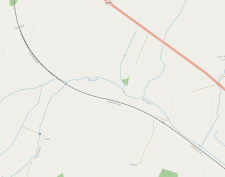
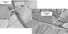
As per this article http://www.countytimes.co.uk/news/16314397.talerddig-new-railway-bridge-is-opened/ two new bridges at Talerddig replace four occupation crossings. I traced the route on GPX, and drew them on MC as well as OSM, as well as amending the new closed roads. This is how it should look: https://www.openstreetmap.org/search?query=Talerddig#map=16/52.5785/-3.5683 and as per the attached screenshot of OSM.
Someone’s gone and deleted one of the bridges I drew, and most of the new roads. The road bridge to the NW of the site is (thankfully) untouched, but all the other road changes I’ve made have been deleted, and the road system https://mapcreator.here.com/mapcreator/52.57874814096502,-3.573195374221797,16,0,0 was an utter mess.
I’ve now redrawn the new roads in this area from my GPX and site surveys. Please DON’T delete or amend it.
 Gordon HERE Map Master (Ambassador) • July 16, 2018 at 12:44 am UTC
they were probably removed as they are showing as level crossings not bridges on latest satellite data. if you can take images of each bridge and exact locations then they will be accepted until then it looks like your edits are wrong as bridges dont show. in cases like this you need to supply photographic evidence
 Ben (HERE Moderator) • July 16, 2018 at 10:04 am UTC
Hi Richard,
I’ve endorsed all these changes you’ve made. The latest internal-imagery shows these bridges are clearly under construction so I’m unsure why the south eastern one was removed.
Thanks again,
Ben
 Richard Jones • July 16, 2018 at 12:21 pm UTC
I have dashcam footage when I drove around both bridges last Monday if you need the proof.
 Gordon HERE Map Master (Ambassador) • October 7, 2018 at 9:54 pm UTC
Richard,
does the original roads that used the unbarriered railway crossing prior to the bridges being built still exist?, and accessible to farm traffic or pedestrians? if yes can you draw them as tracks. they wont be used for vehicle navigation but still show for pedestrian crossings.
For example does the crossing at the maintenance yard still allow access for pedestrians or emergency vehicles or is it completely sealed off? Richard Jones • October 11, 2018 at 10:56 am UTC
The NW road bridge replaced a crossing next to the NR compound. The access road still runs to the compound and the former station cottage next to it. On the other side of the track there, a farm track runs through the field up to where it used to cross the railway.
All other crossings SE of the compound have been closed. Just SE of the 2nd new overbridge there used to be a 2nd farm crossing immediately next to an underpass (cattle creep). The cattle creep is still there, and is also used as a pedestrian access under the railway. The third crossing to the SE (just before the road swings due south to Pikins farm) is also closed.
In short, all crossings (foot and road) between the Carno level crossing, and the foot crossing to the east of Talerddig farm (where the railway, road, and river are in closest proximity) are all now closed, except for that one cattle creep underpass next to what was the Pikins farm l/c. The changes on here.com should exactly mirror what I’ve drawn on Openstreetmap:
https://www.openstreetmap.org/#map=15/52.5790/-3.5661
There’s a separate issue I need to raise about the A483 Llandrindod Wells road just south of Newtown, Powys. The road layout has changed significantly because the northernmost of the two roundabouts here has now opened. I can’t change the road geometry because it’s locked. Someone at Here.com will need to draw it from my recorded GPX file.
 Gordon HERE Map Master (Ambassador) • October 11, 2018 at 5:29 pm UTC
all roads due to the bridges have been sorted so should be accurate now, but as for the last part the newtown part i dont understand what parts you mean so will leave that to Ben to sort that out.
There is lots of farms that are missing access roads in and around carno and talerddig, can you please draw them in and i will approve them, just draw them as residential roads even if unsure they are tracks or not and I will look at them as have slightly better access to latest satellite images,.
You must be logged in to reply to this topic.

