Forums › Western Europe › Belgium › How do we report road closures so that it gets to the end user quickly
-
 Rudy B • January 11, 2020 at 11:19 am UTC
Hi,
On december 20 2019 a road called Oprit was closed in Ostend, Belgium for all motorised traffic.. This because the bridge it leads to, is not longer safe for that sort of traffic.
I reported this on december 19th (the day before the actual closure) using the special icon (report closures, constructions events). in Map Creator.
I thought this would find its way to the end user quickly via traffic information or some other quick tool.
However today on jan 11, I find that this road section is still used by HERE we go web when it calculates a route.
When I activate the layer ‘road closure reports’ in Map Creator, my closure report is shown on the map.Was I mistaken to assume that this way of reporting would find its way to the end user quicker than by the usual map updates ? If so why do we need to report this with this special icon, as the downside seems to be that we have no follow up on things we report there.
Thanks
R. Borrey Gordon HERE Map Master (Ambassador) • January 11, 2020 at 5:07 pm UTCthere is a few things you have to factor in when making this kind of report. Is the whole road closed or on just the bridge,. If it is only the bridge then that is the only part that should be marked as closed as if vehicles have access to that road for houses prior to the bridge then closing the whole road limits their access if the whole road is closed.
When making reports like this you have to provide official links to support your closure otherwise staff will struggle when trying to verify its genuine
as for how long it takes to action a report then that is an open question, its all to do with who is checking the reports, the verification of the report and then it getting added to the system. It is not an instant process so there could be a delay in adding traffic reports as its dealt with a completely different department than the moderation of edits on mapcreator, Rudy B • January 11, 2020 at 6:06 pm UTCThanks for your response Gordon.
I did add a link to an official report about the closure. It is in Dutch though. But I guess the people checking, will use a translation tool.
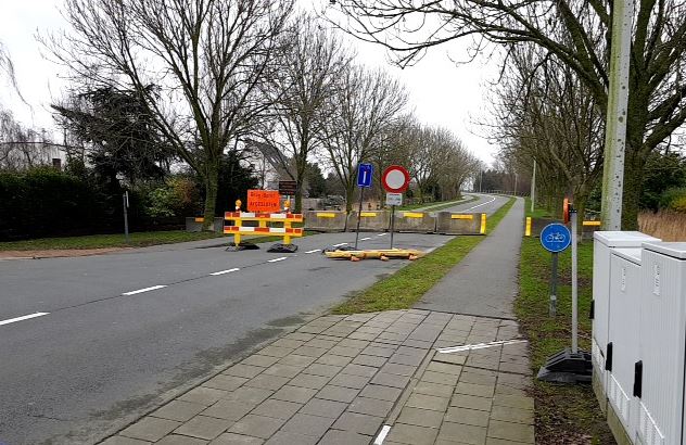
I only marked the section closed that is actually blocked. There also are some pictures in my Geospace illustrating the blockage (added one below)
Most important to know for me is that this way of reporting is supposed to go quicker than normal Map Creator edits. For the rest all we can do is wait for the processing to complete.Thanks
R. Borrey Gordon HERE Map Master (Ambassador) • January 11, 2020 at 6:23 pm UTCjust to be on safe side send an email with the exact location and also any images and documents you have to mapcreatorbenelux@here.com local language experts will be able to read and deal with them quicker
The closure took is quicker than conventional ways but is still not an instant thing. Unlike normal edits there is no way to tell if your report has been successful or not as you do not get feedback as its an internal system that deals with this
If its a longer term closure or is a more complex issue then its best to send an email with as much information as you can and local country HERE staff can deal with it quicker
-
This reply was modified 4 years, 3 months ago by Gordon HERE Map Master (Ambassador).
-
This reply was modified 4 years, 3 months ago by
You must be logged in to reply to this topic.