Forums › Eastern Europe › Czech Republic › Highway road vs. main roads in Cyech Republic
-
 Adam Step • October 16, 2017 at 9:33 am UTC
Hello,
in last weeks I have changed several roads in Czech Republic }D0, D4, D6 and D7 for instance] from ROAD to HIGHWAY as they are marked by traffic signs. Unfortunately now the map marking is again back to ROAD. What should I do in order to keep them marked as HIGHWAY permanently? Thanks for a hint.
HERE Map Creator Konstantina Kokkalis • May 16, 2019 at 12:04 pm UTCDear Adam,
Please accept our sincere apologies for the really late reply; We’d hoped to get back to you sooner, but due to system issues, we do not receive notification for topic submissions. This makes it hard for us to trace them all on time. Our company is working on improving this. Do you still have issues?
Regards
Adam Step • May 24, 2019 at 6:11 pm UTCHelo Konstantina,
Yes, I still face the same issue. I have changed part of D4 to HIGHWAY, after three days it reverts back to MAIN. Any hint?
Thanks
HERE Map Creator Konstantina Kokkalis • June 5, 2019 at 7:54 am UTCHello Adam,
can you please provide me some coordinates of the specific locations were you have been trying to make these updates so i can request an investigation?
Thank you Adam Step • June 5, 2019 at 8:14 am UTCHello Konstantina,
for instance here, both directions: https://mapcreator.here.com/mapcreator/49.700286527779184,14.081119637023335,18,0,0,normal.live
I changed it to Highway, a week later it was swappwed back to Main. And it was for a long stretch, lets say 15 km (lot of segments).thanks for investigation, Adam
HERE Map Creator Konstantina Kokkalis • June 5, 2019 at 9:00 am UTCGreat, thank you Adam.
I have requested an investigation for this and come back to you as soon as i have some update. Just keep in mind that as you can see if you place your mouse over the (i) button next to each category of the Road Type drop down list, as highway, at HERE, we consider any main road with the maximum legal speed limit that runs between larger cities, states or countries. Route 5, which connects Czech Republic with Germany via route 6, is a Highway.
Any major road with a faster speed limit that runs through urban areas or between cities, is considered one level down.
So even if a highway sign is presented on a road, this does not necessary mean that it should be classified as a “Highway” in HERE maps Adam Step • June 18, 2019 at 1:53 pm UTCOK, I got your point.
Is there any reason for such a road category that does not follow reality? In my eyes such maps are useless, they represent some fiction , not a real road system.Why should be this highway: https://mapy.cz/s/3tWtm
be marked differently that that one? https://mapy.cz/s/3tWtWSame category, same speed limit, same restrictions, but different category in Here maps.
The reason I ma complaining is that a derivative from HERE maps is used in my car built-in navigation system and was trying to fix it. Do you thing there is a way to change that? Thanks Adam
Giles Birch • June 18, 2019 at 2:59 pm UTCI agree with Adam.
Here is Dubai our lagest roads that run through the city are considdered “Major Roads” when in fact they are Highways. The issues now is that so many roads are considdered “Residential” that my in-car navigation takes me through all the annoying streets when other better roads that are a level up are considdered the same as resisdential street, which is simply stupid.
You really need to re-think your road classification. I’m stuck using your maps in my Landrover and it sucks. I am trying to do my best to improve it.
This probably explains why Waze is well ahead of Here in the same game.
-
This reply was modified 4 years, 10 months ago by Giles Birch.
HERE Map Creator Konstantina Kokkalis • June 21, 2019 at 8:44 am UTCHello Adam and Giles,
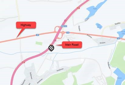
I totally understand the way you see it. Indeed, the classification may confuse people. But, the truth is that this classification is connected only with the functionality and connectivity of the roads. This explains the information provided for each Road Type. Highways connect larger cities, states or countries. Main Roads run through urban areas or cities. What’s behind the way a navigation calculates routes, is totally different. There are many parameters and algorithms used for this purpose. From speed limits to speed categories, from options chosen from the driver (avoid tolls, avoid unpaved roads etc and from many other attributes that we use and are not visible in Map Creator. You can see this from the attached image, which is a screen shot from the indicated location. Route 4 which in reality is a Highway (as indicated by signs) but you see it in Map Creator as “Main” is presented thicker and darker than Route 18 which is categorized as a “Highway”. So basically, Route 4 is a “higher level” road even in our database. And such roads are always preferred by navigation systems for routing. But of course, keep in mind that this also depends on the routing options set up by the driver and the algorithms each system uses -
This reply was modified 4 years, 10 months ago by
You must be logged in to reply to this topic.