Forums › North America › United States › Does Here set speed limits as they exist or how they want them to be?
-
 Dana Archer • June 13, 2018 at 4:36 am UTC
Serious question: How do I get Here reviewers to correct this? I'm a long-time editor for a competing app and I know what I'm dong. It's irritating to have my in-vehicle nav system display the wrong information.
This section of Hwy 18 all the way to the Big Bear Dam is 55 MPH. I've set it as such but it it always disapproved by reviewers. I don't know what to do because there seems to be no way to communicate with or appeal a decision by reviewers. I'm highly familiar with this road and the speed-limit signs are clearly posted and can be viewed in Google Street View. This section falls under the "55 MPH rule." California Driver's Handbook: "The maximum speed limit on most California highways is 65 mph. You may drive 70 mph where posted. Unless otherwise posted, the maximum speed limit is 55 mph on a two-lane undivided highway and for vehicles towing trailers."
Vehicle Code Section: 22349.
(a) Except as provided in Section 22356, no person may drive a vehicle upon a highway at a speed greater than 65 miles per hour.(b) Notwithstanding any other provision of law, no person may drive a vehicle upon a two-lane, undivided highway at a speed greater than 55 miles per hour unless that highway, or portion thereof, has been posted for a higher speed by the Department of Transportation or appropriate local agency upon the basis of an engineering and traffic survey. For purposes of this subdivision, the following apply:
(1) A two-lane, undivided highway is a highway with not more than one through lane of travel in each direction.
(2) Passing lanes may not be considered when determining the number of through lanes.
(c) It is the intent of the Legislature that there be reasonable signing on affected two-lane, undivided highways described in subdivision (b) in continuing the 55 miles-per-hour speed limit, including placing signs at county boundaries to the extent possible, and at other appropriate locations.
(Amended by Stats. 1999, Ch. 724, Sec. 41. Effective January 1, 2000.)
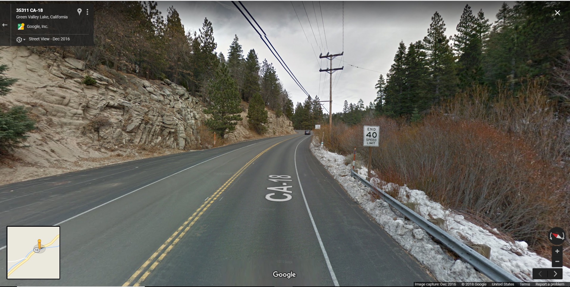
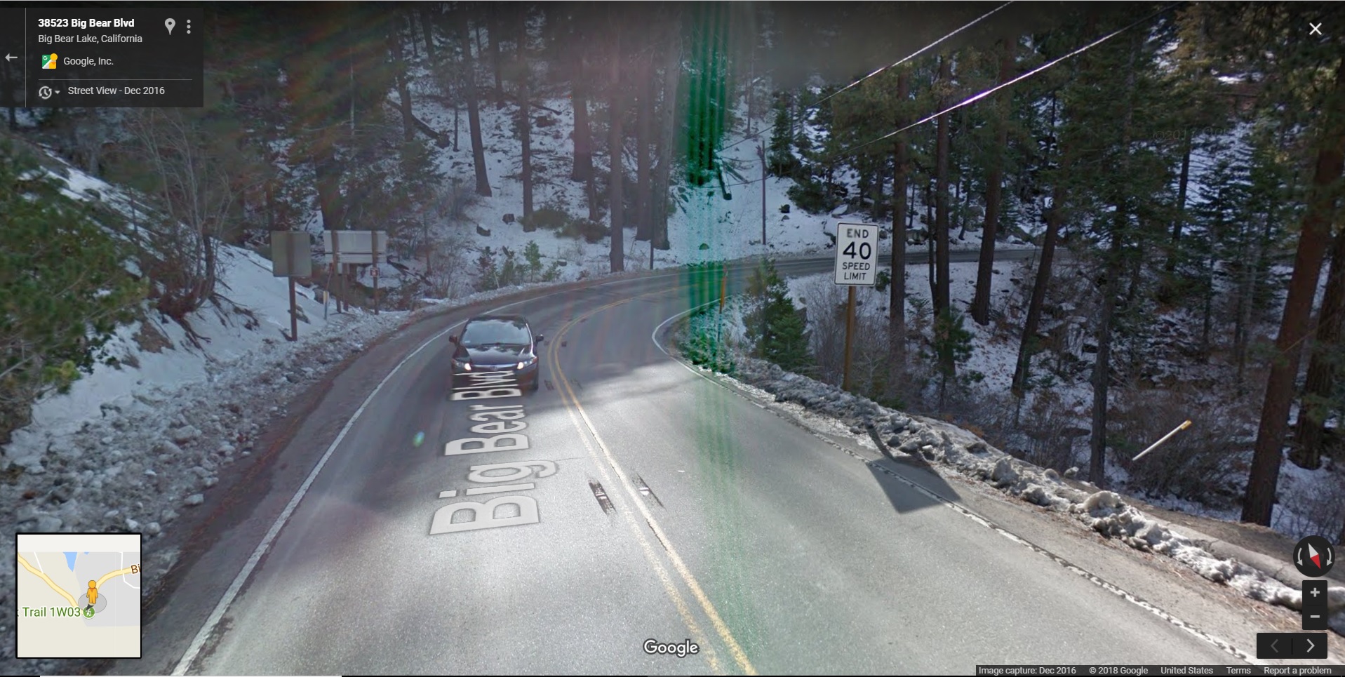
Dana Archer • June 13, 2018 at 7:28 pm UTCCorrection: The 55 MPH limit extends east, past the Big Bear Dam, to the city limits of Big Bear Lake. Photos showing the ends of the 40 MPH limits (where the 55 MPH limit begins) on CA-18 at Green Valley Lake Rd and at the Big Bear Lake city limit are attached.
C Lewis • June 17, 2018 at 3:09 am UTCHey Dana,
I’ve had the same issues in the past as well. I’ve found that sourcing the edit with a picture of the speed limit sign helps. There are two ways that I know of doing this:
First, HERE has collaborated with Mapillary to collect street-level pictures (similar to Google maps). These images are viewable by any editor by clicking the compass/arrow icon in the bottom right corner. If Mapillary users have mapped the road, a waypoint will be displayed on the road, on which you can click to view the captured imagery. Unfortunately, there’s no way to indicate to the reviewer that they should look at this data, but hopefully, if they’ve been around long enough, they know to look there. One of the things that sets Mapillary apart from a generic picture hosting service is that they extract traffic signs (including speed limit signs) and other data (see their website) from each image. If you click the layers icon in the top right corner and activate “Mapillary Traffic Signs” under “support layers,” signage of a captured area will be displayed. Again, it only helps if the reviewer knows to check these sources, but this can be helpful to you as a reviewer or editor in the future.
Second, if there is no Mapillary data for the road you are editing, you can upload a personal picture from your computer. I know of editors that have taken screenshots of a competitors street view imagery, cropped out watermarks, and used the image to source their edit. Technically, this is against copyright law and HERE does not condone it; I’m just saying I know it’s been done in the past. To upload a photo, make your change to the road, but prior to clicking save, look for the picture icon on the right side of the “road attributes” editing pane. Follow the prompts to upload the photo from your computer. When you upload, HERE will ask you to move the image to where the object is in the real world. After saving the photo, go ahead and click save on the edit. These pictures are only viewable by HERE’s internal staff for edit verification, but if you decide you want to delete an image, you can do so from the “Your geospace” tab on the left.
With that said, there is a way to challenge a denied edit. On the left side of the screen, click on the X icon titled “your stuff” followed by the bullet list icon titled “your feed.” Click on whatever edit was denied, and above the satellite image thumbnail you should see “reopen.” Click that, add your reasoning and indicate how the edit can be verified (personal knowledge, indicate that Mapillary images were used, etc.). This should fire it off to the HERE team.
If you’re new to the HERE community, welcome and we hope you stick around.
-
This reply was modified 5 years, 10 months ago by C Lewis.
Dana Archer • June 17, 2018 at 11:51 pm UTCThanks for the detailed response and the helpful information. I’ve been submitting edits here and there for the last seven years or so, at least a few years before Navteq became known as Here. As a prolific editor for another mobile app I would find some pretty significant map errors and then I would (and still do) submit them when I found that Navteq (Here) had the same errors.
Now that my wife just got a new car that with in-vehicle navigation that displays speed limits, I’ve discovered that frequently the SLs are either wrong or most often, non-existent. I actually started submitting SLs in my neighborhood a year or so ago when I found that was an option. Recently I became more interested in correcting the map, so I’ve submitted a huge number of SLs in the areas I frequent. Many of them seem to be accepted, but many of even the most apparent and logical of them are rejected. Makes me feel like I’m wasting my time.
Do editors develop a “trust level” of sorts? I’m #53 in the U.S. I can attest that my accuracy level is high.
A few things I simply just don’t understand. For example: There are inconsistencies with SLs on freeway on- and off-ramps and transition roads. In California, they are all nearly all technically 65 (some I know are 55 in the Los Angeles area) unless posted with a speed-limit sign, not simply a yellow “advisory” sign.. This is rare in my experience. Yet, Here has some at 40, some at 45 or even 25, and some at 65. I’ve submitted 65 to freeway transitions and they are rejected within a day. I won’t (and can’t) go over stuff over and over again and continue to not make progress.
I’ll look into the suggestions you’ve made and see how it works out.
C Lewis • June 18, 2018 at 3:20 am UTCSeems like you and I do this for the same reasons. I also contribute to several other competitors and submit corrections when I see that HERE’s database also needs updating. And I know the struggle of fighting to have logical edits included. Some edits are reviewed by other members of the map creator program, so that could be where the issue comes from and where the “reopen” option could come in handy if your edits are repeatedly denied. I could be wrong, but I think any member can review another member’s edit. And if the reviewer isn’t accustomed to researching the edit, they may reject something that’s correct. I know how frustrating it is. You can see what edits are available for you to moderate by enabling “map alerts” under the layers icon.
I do not believe we are given a trust level, unfortunately. I have also moved up there in rank with the time that I’ve spent here, but I don’t think accuracy or the number of edits you’ve submitted ever comes into play like it does on other platforms; I think we’re all kept on the same playing field. It would certainly make it easier for the repeat editors, though, if edits were reviewed with less suspicion and hesitancy. Things would be resolved a lot more quickly.
When it comes to the speed limit issue, the advisory speeds should not be applied to a road. This is because those signs are suggestions to drivers rather than an enforced speed limit. So if you see those applied to off-ramps, the entry in the speed limit section should be deleted. The “average speed” can be changed to reflect the advisory, however. With the “transition areas” are you referring to ramps or are they more secondary roads?
Also, just a heads up, it can take up to a year in some cases for edits made in HERE’s database to trickle down to third-parties. Depending on where in the publishing cycle HERE is with their map, it can be up to 2 or 3 months for an edit to officially appear in HERE’s database. Then that data is sent off to third parties (Garmin, car manufacturers, etc.) who use the data to make changes to their own maps, which can take another 3-6 months for processing before the final update is ready for the consumer. But, I’ve found it’s worth it when you see edits you made show up.
If you have more questions, I’d be glad to answer them as best I can.
Dana Archer • June 18, 2018 at 10:20 pm UTCI’m primarily referring to “fly-over” transition ramps from one freeway to the next. They are nearly all the same speed limit as the freeways they are connecting. It’s mostly 65 around here but HERE has them all screwed up; most appear to follow the advisory signs. I just submitted corrections (again) to the I-405/SR-118 interchange because that is a mess with regard to speed limits on the map.
I’m guessing that anything that I’ve submitted recently that survives the reviewing process won’t show up on my wife’s car till the map update comes out in September or October of 2019.
C Lewis • June 19, 2018 at 2:11 pm UTCI agree those all sound like logical edits. Best of luck getting them approved.
Dana Archer • July 13, 2018 at 11:43 pm UTCC. Lewis: My frustration level with HERE reviewers has reached an all-time high. They continue to reject my edits that prohibit turns across raised concrete center dividers and reject a one-way road that HERE has as two-way. I beg and plead on the “reopen” request and they get rejected. The satellite and Street View images are CLEAR. I have actually tried to send a message to the map quality-control head to see what he can do. I sent it yesterday and have yet to here back. Waze and Google Maps are going to eat HERE’s lunch if it doesn’t make minimal effort to correct to produce a decent product. If you want to “adopt” a neighborhood around Newhall, California that includes the area of Newhall Avenue, maybe you can “approve” my edits and maybe that will help.
C Lewis • July 16, 2018 at 4:16 pm UTCI can understand the frustration and I will see if adopting that area and reviewing edits helps. For the turn restrictions that you are adding, are they done to roads that have a dotted line down the middle? If that is the case, the turn restrictions, though correct, are likely denied due to double information. See the bottom of this page: https://mapcreator.here.com/mapcreator/help/roads-and-road-structure/add-a-road/
The dotted line is a non-editable feature that indicates a median or structure blocks turns on that road. And even though an intersecting road may not have a turn restriction visible, the dotted line indicates that said turn is not possible. It really is confusing that the turn restriction is not identifiable in this way (I too had a lot of problems with turn restrictions like this being denied until I understood the purpose of the dotted line), and I think it is something that should be changed on the user interface to make things more clear.
C Lewis • July 16, 2018 at 5:49 pm UTCAlso, a reminder that with off-ramps it is better to set the speed limit to “null” than to have it at the speed of the highway since technically there are no speed limits for off-ramps. Instead, you can change the average speed to match the yellow, recommended speed limit signs posted on the off-ramp.
Dana Archer • July 16, 2018 at 11:00 pm UTCThanks for the explanation of the dotted line. I thought it was a bug in the program because I saw it only sometimes. So, now, it seems that some of the “allowed” turns are actually not. But that raises another problem: That some of the turns that should be allowed are not really allowed because of the dotted-line restriction.
As for ramp speed limits, they’re all over the place here. There are almost none that are “null”; the others are either at the mainline speed or are at the “advisory” speed, or are at a speed that HERE just made up. Some longer ramps even have two or three SLs on the same ramp!
Also: I “approved” your 55 MPH edit on The Old Road. I’ve been trying to get that corrected for some time.
C Lewis • July 19, 2018 at 2:55 pm UTCThanks for approving that; hopefully it goes through. And I guess the best solution for those ramps is to slowly try and change them to “null”. I will try and help with that as well if I see them set that way
Dana Archer • July 19, 2018 at 7:49 pm UTCThanks for your help. Is there any way we can take this conversation offline? I’ll post a link to an image file showing my email address and you can contact me that way. Here you go: https://photos.app.goo.gl/Af3mEpex9thd6Xdy8
Stven Roger • April 10, 2024 at 1:18 pm UTCCustomer satisfaction surveys are a valuable tool for businesses to gather direct feedback from their customers. These surveys typically ask customers to rate their experience with a product or service and provide comments on their overall satisfaction. By analyzing the survey responses, businesses can identify areas for improvement and make informed decisions to enhance the customer experience. Additionally, customer satisfaction surveys can help businesses measure customer loyalty and identify potential issues before they escalate. Businesses need to design surveys that are clear, concise, and easy to understand in order to gather accurate and meaningful feedback from their customers. Get a chance to win a free Donut by taking the official survey at https://www.dunkinrunsonyou.com.co/.
Sam Smith • April 12, 2024 at 3:58 pm UTCNeed a skilled mobile app developer for your project? Look no further! Check out GloriumTech’s top mobile developers at https://gloriumtech.com/hire-the-top-mobile-developers/. They’re ready to bring your app idea to life! 📱💡 #MobileApp #Development #TechTalent
-
This reply was modified 5 years, 10 months ago by
You must be logged in to reply to this topic.